| Previous Date | Day By Day Index | 16th OVI Home Page | Next Date |
Where was the regiment on
Friday, May 20, 1864
On this day, the 16th Ohio and Banks' entire army crossed the Atchafalaya River at Simmesport, Louisiana. Lt. Col. Joseph Bailey, maker of Bailey's Dam at Alexandria, had now orchestrated the building of a bridge across the river made up of 22 steamboats, side by side across the river, and with a road built of planks across their bows. Cpl. Theodore Wolbach, Company E, describes the day:
We crossed on the morning of the 20th, marched down stream, and laid all day while the army was crossing. When we went back there in the evening every thing was over and the troops gone toward the Mississippi. No living thing was left on the other side, save a few dogs that were sniffing around over the abandoned camp grounds. Five gunboats, once in a while, sent a shell into the opposite woods near the late crossing, but elicited no response. We brought up the rear and followed the main force about dusk. The marching was not hard. There were frequent halts but no chance for sleep.
The regiment resumed its march toward the Mississippi River at 5:00 pm, and marched all night, acting as the rear guard for the large Union procession.
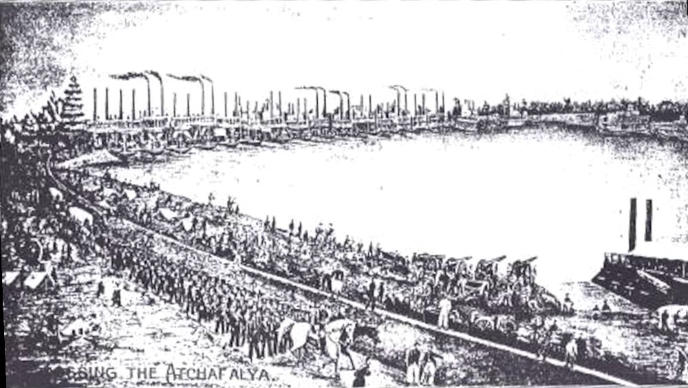
Below is a sketch of the crossing of the Atchafalaya River at Simmesport, Louisiana, May 20, 1864, by Gen. Banks' troops, over the steamboat bridge, built by engineer Lt. Col. Joseph Bailey. This sketch by John Needham Bellchamber of Company C, 119th Illinois Infantry and held by the Illinois State Historical Society, Springfield, Illinois.
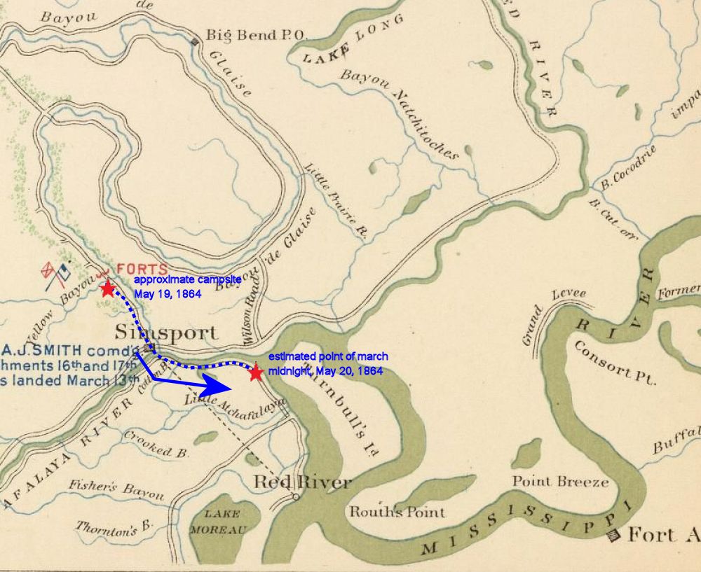
This period military map shows the approximate route taken by the 16th Ohio and other troops under Gen. Nathaniel Banks as they crossed the Atchafalaya River and moved east and south toward the safety of the Mississippi River. The troops marched all night and the estimated location of the 16th Ohio at midnight on May 20, 1864 is shown.
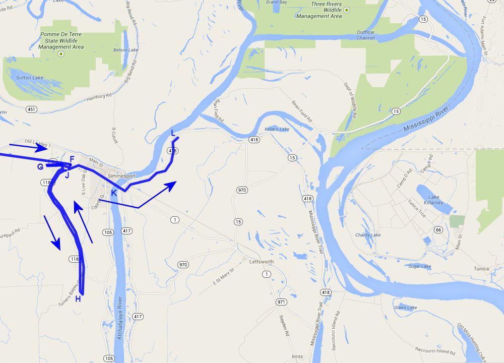
Modern day close view map shows the approximate route taken by the 16th Ohio and other troops under Gen. Nathaniel Banks as they crossed the Atchafalaya River and moved east and south toward the safety of the Mississippi River. The troops marched all night and the estimated location of the 16th Ohio at midnight on May 20, 1864 is shown.
F - Approximate location of the 16th Ohio when it camped for the night of May 17, 1864, just east of Yellow Bayou, Louisiana.
G - Approximate location of the 16th Ohio when it camped on the battle line of the Battle of Yellow Bayou, on the night of May 18, 1864.
H - Approximate location of the 16th Ohio where it spend part of the day in battle line guarding against any flanking movement by Gen. Richard Taylor's Rebels on May 19, 1864.
J - Approximate location of the 16th Ohio where it camped for the night of May 19, 1864, near the crossing of Yellow Bayou, Louisiana.
K - Location of the steamboat bridge where the 16th Ohio and all of Gen. Nathaniel Banks' troops crossed the Atchafalaya River on May 20, 1864.
L - Estimated location of the 16th Ohio at midnight on May 20, 1864, on its all night march toward the Mississippi River.
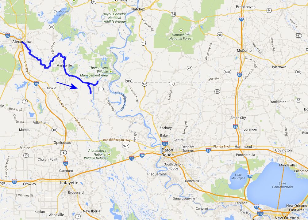
Modern day wide view map shows the approximate route taken by the 16th Ohio and other troops under Gen. Nathaniel Banks as they crossed the Atchafalaya River and moved east and south toward the safety of the Mississippi River. The troops marched all night and the estimated location of the 16th Ohio at midnight on May 20, 1864 is shown.
| Previous Date | Day By Day Index | 16th OVI Home Page | Next Date |